Dartmouth College Library Bulletin
SOON AFTER receiving the town charter on 4 July 1761, the proprietors voted to
mark out the Town lotts in the Town of Hanover according to the requirements of the Charter . . . also to lott out the meadow land . . . Iikewise to lay out another Division in sd Township . . . and to make proper allowance for highways between Lotts.1
They delegated a committee of five, led by surveyor Edmund Freeman, Jr., to divide the land into rhomboid-shaped lots in conformity with the roughly rhomboid shape of the township. The first divisions were house lots along proposed streets for a Center Village in the Town Plot, which never materialized, and meadow lots along the east bank of the Connecticut River. These were followed by the first, and later second, divisions of hundred-acre lots, and, subsequently, by the sixty-acre and, finally, fifty-acre divisions. The scattered pieces of remaining undivided land, mostly in the Moose Mountain region eventually were sold to Jonathan Freeman, a prominent citizen of the town.
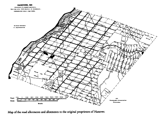
In recognition of the need for publicly-owned roads and in conformity with the town charter, which required that an Allowance is to be made for High Ways,the proprietary withheld many strips of land bordering on lots for roadways or for compensating landowners by exchanging land from the strips for land across private property where necessary roads might be laid (see map). In addition, it reserved land within numerous lots, marked R on the map, for roads but without specifying their exact locations. Far more land was withheld and reserved for town roads than most people realize.
The town charter and the proprietary clearly intended that landon which roads were laid would belong to the corporate town, not to abutting landowners. Subsequently,
the exchange of land owned by the Town for land on which a new highway was to be located was specifically recognized by an act of the New Hampshire legislature in 1791 which authorized the sale or exchange of any land remaining after a highway had been discontinued for the purpose of acquiring land on which a more convenient highway could be located. This statutory authority remained in effect until 1829. 2
Not only the proprietary and the residents of Hanover but also the new state legislature recognized that land underlying the old roads belonged to the corporate town. The more recent term right-of-way was not applied to these old roads.
The only exception among early roads in Hanover of which I am aware is Great Hollow Road for which Chauncey Bridgeman, on 31 August 1818, relinquish[es] & quit claim[s] to the use of the town . . . so long as the same shall be used as a public highway reserving to myself the timber on said land except what is wanted to make and repair said road through my land.3 Today that provision would be interpreted to mean the town had been given a right-of-way on private land.
Initially, Hanover roads were laid and trod where landowners found them most convenient to visit one another, go to market, attend church services, and participate in town meetings. Thus many of the early road surveys were made not to lay out proposed roads but rather to determine how much land should be exchanged from road allowances to compensate landowners for the land on which the road had already been laid and trod. However, the compensation sometimes would be made many years after the survey. As an illustration, Paine Road lies on a strip of land about one mile long and so feet wide, today largely on Hanover Water Company land. It was part of Highway No. 18 of the First Assignment that had been surveyed in October 1782, but compensation for the underlying land was not made until February 1794.4 Part of a road would often be laid directly on an allowance; therefore, no survey would be necessary for that section. On the other hand, part of a road would sometimes be laid across a lot where the proprietary had reserved land for roads; although the road might be surveyed, no land would be exchanged.
With surveying instruments of the eighteenth and early nineteenth centuries, such as plane tables and surveying compasses, angles usually were measured to the nearest degree and directions were read relative to the direction of the north magnetic pole of the earth. Furthermore, distances between stations were recorded in whole numbers of rods (1 rod = 16.5 feet) and often were measured by pacing. It should be understood that in those early days surveyors of Hanover's country roads had no need to correct compass readings for true, geographic north nor to measure distances to fractions of a rod for determining amounts of land to be exchanged.
From a study of the proprietary, town, and road records and extensive field work, James W. Goldthwait produced a study of Hanover roads, published as an appendix to J. K. Lord's History of Hanover.5 Professor Goldthwait begins: The network of roads over Hanover township is a compromise between a desire to follow a geometric pattern and a willingness to accept the control of hilly topography. The latter dominates. He continues by providing an excellent summary of the history of Hanover's town roads followed by a brief description of each one and includes a map showing the location of most of them. He admits to inaccuracies and omissions -- there are several -- and that much more work should be done. To identify the roads, he develops a numbering system based on the chronological order of their surveys or recording of them as found in Highway Allotments 1777-1889. The Town of Hanover later adopted a modified version of this system.
The comment by Professor Goldthwait that compass bearings [in Hanover's early road surveys] are almost always referred to true north, but may be in error three or four degrees,6 is, in my opinion, a misinterpretation. It is highly unlikely that early surveyors corrected their magnetic north readings to true north. Goldthwait's error arises from a curious circumstance. Whereas today in Hanover the angular separation of magnetic and true north (declination) is approximately 15° west, about the year 1795 it was approximately 0° as can be determined from the average values of declinations for Boston and Albany that year. As a matter of fact, during the century between 1760 and 1860 the declination varied irregularly between approximately 3.5° east and 4.3° west. It is this natural small variation along with the assumption that compass readings were corrected to true north which lead to Goldthwait's misinterpretation. Since 1860 the declination has varied greatly until it is now 15° west.
As an illustration of early road surveys, consider Goldthwait's highway number 38, which is recorded as Highway No. 9 of the Second Assignment:
We subscribers Select Men of the town of Hanover have surveyed, laid out and established a highway from the County Road so- callednear Jonathan Bearces to Tim Owens Viz: We began at a pine stub near said Bearces on the Ely side of the road run N 4° W 25 rods to a large pine- then N 10° W 12 rods to a large rock then N 24° W 18 rods to a large pine root then N 23° W 45 rods to a large pine-then N 5° W 42 rods to a Hemlock- N 5° E 25 rods to Hem.- then N 36° E 13 rods to a beech- then N 8° E 16 rods Hemlock-then N 54° E I4 rods to a beech- then N 18° E 24 rods to a stake then N 70° E 39 rods to stones- then N 41° E 42 rods to a rock and stones- then N 82° E 19 rods to the southerly side of the road by Tim Owens -- Hanover Dec. 10, 1795. This road is on the west of the line and is 3 rods wide.Samuel Slade Joseph Curtis -- Selectmen of Hanover7
The opening words suggest the selectmen are marking out a new road. These words sometimes introduce the survey of a road or part of a road already laid and trod. For this road, however, no assignment of land is entered into the highway records; instead, in the proprietary records of 7 February 1803, we find:
Voted that Jonathan Bearce shall have forty-four rods in length & the whole width [10 rods] of the two mile allowance beginning at the Southwest corner bound of the sixteenth hundred acre lot East of said allowance & extending southwesterly forty-four rods in lieu of an assignment heretofore made by the Selectmen for roads through his land.8
As may be ascertained from the survey data, this quantity of land very nearly equals the amount of land occupied by the part of Goldthwait's highway number 38 that passed through Bearce's property.
Points of reference or stations in most of Hanover's early road surveys usually were marked by objects of short-term duration. The survey for highway number 38, for instance, "began at a pine stub near said Bearce's on the E[aster]ly side of the road." The pine stub is long gone and where the Bearce house was located 200 years ago may be difficult to determine. The large pines, pine root, hemlocks, and beech are not likely to have survived. On the other hand, large rocks or manmade features such as stone walls, cellar holes, bridge abutments, retaining walls and road markers may still stand.
In 1982, the Hanover Conservation Commission had surveyor Thomas C. Dombroski of Claremont, New Hampshire, locate the route of highway number 38 from the foregoing original survey data. He drew up a plan of the area with his resurvey superimposed on it. Early this year, the selectmen asked surveyor Kenneth LeClair, Jr., of Hanover to investigate this same road. From his observations and studies, LeClair made a plan of the area showing 'monuments' and also produced a computer-generated plot of the 1795 survey data. These plots and plans of Dombroski and LeClair, now on file at the Hanover Town Office, are in substantial agreement.
Old roads in Hanover often had curious names or unusual features. For instance, the only road in Hanover with two sharp switchbacks was Lover's Lane from Half Mile Road down to River Road in the northwestern part of town. We can easily imagine its romantic lure. There are Visiting and Bridle Roads; roads into Skunk Hollow, Great Hollow, Toad Hollow and Sleepy Hollow; Turnpike and County Roads; Pork Hill, Dogford and Wolfeboro Roads -- all roads that conjure up stories of Hanover's rich history, but these must be reserved for another time.
1. Frederick Chase, A History of Dartmouth College and the Town of Hanover, New Hampshire, ed. by John K. Lord, 2 vols. (Cambridge, [Mass.]: John Wilson and Son, 1891--1913), 1: 167.
2. Letter, 14 March 1987, from Hanover town attorney Laurence F. Gardner to Hanover Town Manager John 0. Stinson.
3. Town of Hanover, New Hampshire, Highway Allotments 1777-l889, p. 28.
4. Highway Allotments, pp. 13, 19.
5. James W. Goldthwait, "Hanover Roads," Appendix 2 of A History of The Town of Hanover by John King Lord (Hanover: The Dartmouth Press, 1928), pp. 303-319.
6. Goldthwait, "Hanover Roads," p. 305.
7. Highway Allotments, p. 21.
8. Town of Hanover, New Hampshire, Proprietary Records, Book 2, p. 23.